
Pilot site 1
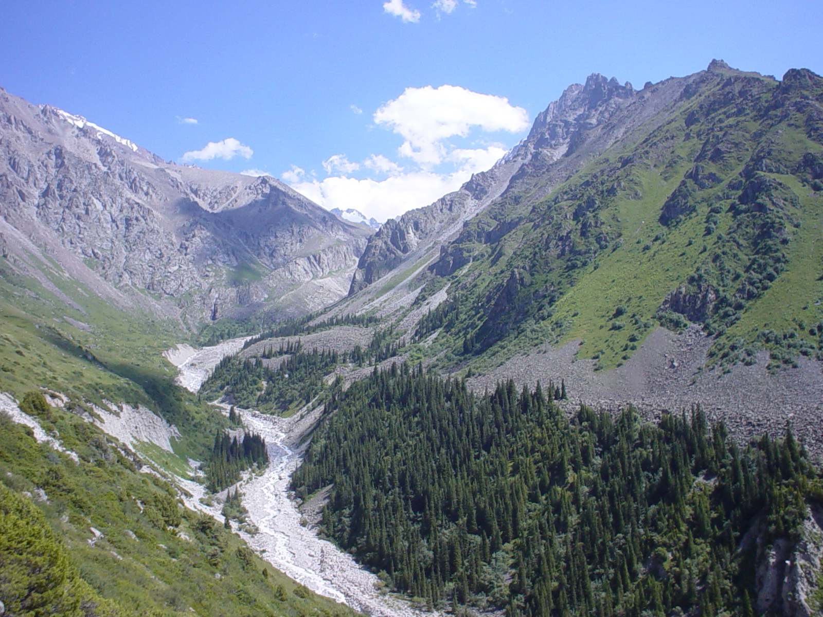
The Ala-Archa River originates in the Ala-Archa Gorge of the Tien Shan Mountains, about 40 km south of Bishkek. It flows through the entire gorge and the city before joining the Chu River. Along its course, the river collects meltwater from numerous glacial and snow-fed streams, including Ak-Sai, Top-Karagai, Teke-Tor, Tuyuk-Suu, Adygine, and Djindy-Suu, before reaching the lowlands. With a total length of 78 km (60 km in a straight line), the river supplies the Ala-Archa and Lower Ala-Archa reservoirs and is used for irrigation of agricultural land. The high-water period typically spans from May to September. In its upper reaches, the river runs through the scenic Ala-Archa National Park, a protected area established to conserve the region’s relic juniper forests and diverse Tien Shan wildlife. The park is also a popular destination for trekking and outdoor recreation.
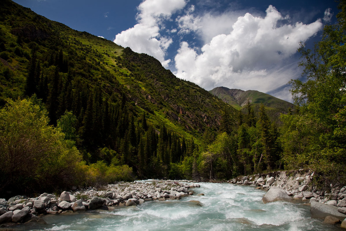
The Ala-Archa Valley has a higher risk of debris flows compared to other valleys in the Northern Tien Shan. These flows are often triggered by sudden outbursts from glacier lakes and intraglacial reservoirs. Almost all side valleys of the Ala-Archa River are exposed to such hazards: Boirok, Kadyrberdy, Karagay-Bulak, Muratsai, Adygine, Aksai, Teketor, Topkaragai, and Dzheldysuu. The most debris-flow-active valleys in the past five years have been Karagay-Bulak, Muratsai, Adygine, and Aksai.
Aksai Lake, located at 3,700 metres above sea level in the upper reaches of the Aksai Valley, together with the Aksai Glacier waterfall, poses a high risk of outburst floods that can transform into destructive debris flows. These events are typically triggered by the sudden release of water from intraglacial cavities, especially during the summer melt season. Such floods pose a threat to the tourist zone situated on the alluvial fan of the Aksai Valley. Debris flows in this valley have been recorded multiple times, notably in July and August of 1960, 1961, 1965, 1966, 1968, 1969, 1970, 1980, 1999, and 2015. The recurrence of these events during mid-July to early August suggests that this is the peak hazard period, coinciding with maximum river discharge.
Teztor Lake, located at 3,750 metres above sea level in the upper Adygyne Valley, is also prone to sudden outbursts. Repeated breaches have caused severe damage to both infrastructure and ecosystems within Ala-Archa National Park. The most destructive event occurred on 31 August 2012, when an outburst triggered a debris flow that partially destroyed the Cherjaz recreation zone. Other recorded outbursts from Teztor Lake include incidents in June 1953, 1968, 1988, August 2018, and 25–26 July 2024. Additionally, on 23 April 2024, a powerful debris flow descended along the Kashka-Suu tributary of the Ala-Archa River. Eyewitnesses described a torrent of mud over 10 metres high sweeping through the valley with great force; the initial surge lasted 15–20 minutes, followed by turbulent flow into the night. More than 25 houses in a nearby summer village were destroyed, plots were buried under debris, infrastructure was washed away, and one fatality was reported.
These recurring events highlight the high hazard level of Teztor Lake, particularly during periods of intense summer melting. The Ala-Archa Valley, especially its recreational zones, remains within a high-risk debris flow area and requires ongoing monitoring and preventive measures.
Adygene Lake is located 10 km from Ala-Archa National Park. Based at the Adygene high-mountain glaciological station (built in 2008 with the support of the Czech Republic), regular monitoring of potentially hazardous glacial lakes is carried out using ground observations and satellite imagery.
Ala-Archa Gorge serves as a key tourism hub, attracting both domestic and international visitors due to its striking natural landscapes, easy accessibility, and well-developed infrastructure. The area offers a range of outdoor activities, with hiking trails of varying difficulty levels that appeal to hikers, climbers, and adventure seekers. The park also holds historical relevance in the field of mountaineering, featuring a dedicated camp and iconic peaks such as Corona Peak and the Peak of Semenov-Tian-Shansky, underscoring its long-standing importance for alpinism and mountain sports.
Given the area’s high visitation during the summer season, population density, and strategic infrastructure in the lower reaches of the river, an Early Warning System is planned for implementation under the GLOFCA initiative. It will enable timely notification of residents and relevant services about impending threats, reducing the risk of human casualties.
Pilot site 2
The Ton River basin is located on the northern slopes of the Terskey Ala-Too Range, in the southern part of Ton District. It is one of the largest catchments flowing toward Lake Issyk-Kul. The river originates in high mountain areas at an elevation of 4,000 metres, in the zone of glaciers and snowfields. The Ton River valley stretches from south to north, passing through mountain gorges, subalpine and alpine belts, and then through foothill and agricultural lands before flowing into Issyk-Kul. The river is mainly fed by meltwater from seasonal snow with a significant glacier melt contribution. The main flow volume is formed in spring and summer due to:
• melting of snow and glaciers,
• heavy rainfall,
• inflow from moraine and cirque lakes in the upper reaches.
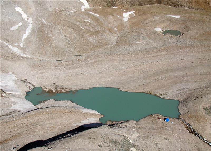
The Ton River basin is considered a high mudflow hazard area. Main causes include glacier melt, heavy rain, and the presence of water-saturated deposits. In the upper reaches are moraine and glacier lakes, some of which present a risk of outburst. In spring, floods are possible due to simultaneous snowmelt in different parts of the basin. When combined with heavy rainfall, the risk of flooding in downstream areas increases significantly. Currently, there are 19 potentially dangerous glacier lakes in the Ton River basin, posing a threat to the village of Tuura-Suu. The degree of hazard of each lake depends not only on the condition of its dam, but also on the likelihood that its outburst flow will transform into a debris flow as it moves downstream.
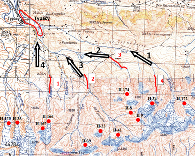
For the village of Tuura-Suu, mudflow threats come from four directions (Fig. 1):
1. Kurumdu
2. Angysay
3. Ton
4. Zyndan-Koltor
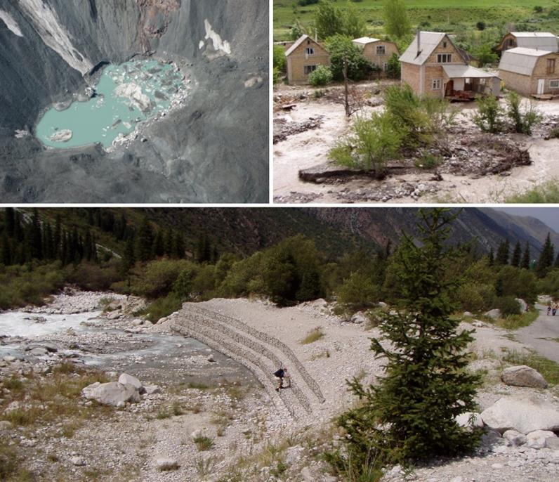
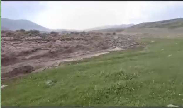
Areas around Tuura-Suu and the Ton River channel are classified as third and fourth-degree mudflow hazard zones: in mid-mountain and low-mountain areas, up to 30–50% of the territory is at high risk of debris flow passage. On 21 August 2024, the outburst of the high-mountain Zyndan Lake caused water levels in the Ton River to rise. Around 400 people (90 residents of Tuura-Suu and up to 70 near the fishery) were evacuated. The Ministry of Emergency Situations, using rescuers and special equipment, redirected the river channel to prevent flooding of houses. The situation was brought under control, and no casualties were reported (Fig. 2).
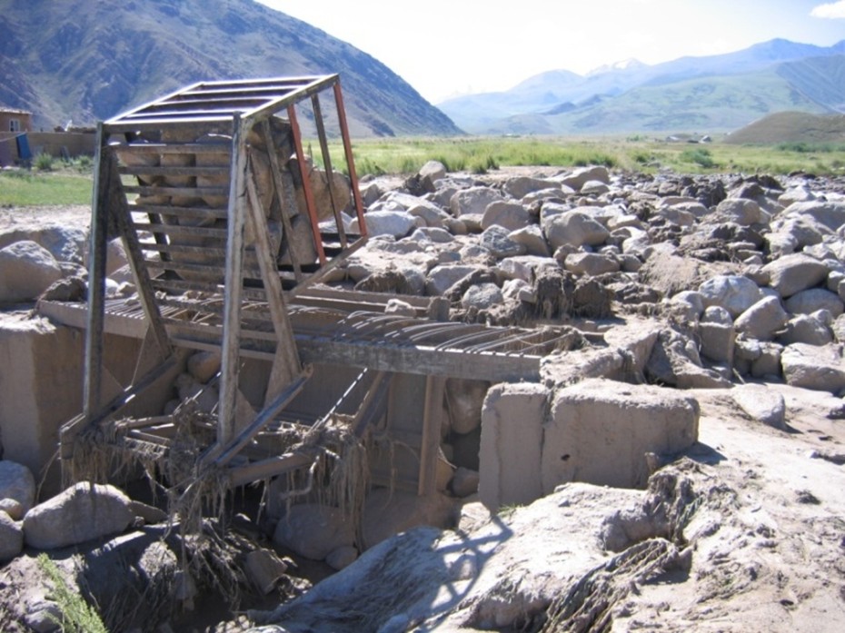
Previously, in 2008, the Zyndan-West Lake (catalogue number I-167) burst. The outburst flow transformed into a debris flow while passing through the source area, increasing its discharge multiple times. On the foothill plain of the Ton depression, where the Zyndan River flows out, the debris flow transformed into a debris-flood, destroyed the gates of the water distribution facility, and buried household plots on the eastern outskirts of Tuura-Suu under rubble and sand (Fig. 3).
In the Ton–Tosor valley, continuous remote monitoring is conducted to track changes in lake conditions and forecast potential threats.
In August 2024, after heavy rains, the water level in Zyndan-Too Lake rose sharply, leading to its outburst. The debris flow created a flood risk for Tuura-Suu. More than 400 residents were evacuated from the danger zone and temporarily sheltered in schools in neighbouring settlements. The water flow was promptly redirected into the Ton River channel, avoiding large-scale flooding and minimising damage.
The Ton River is of great importance:
• for irrigating pastures and agricultural land at the mountain foothills,
• as a source of drinking water for nearby villages, including Tuura-Suu,
• as an object of ecological and hydrological monitoring,
• as a potentially hazardous area requiring systematic observation.
Given the large catchment areas of the Ton and Tosor rivers, as well as the presence of settlements along their courses, under the GLOFCA initiative, additional adaptation measures are planned, including engineering solutions. To protect Tuura-Suu from destructive debris-flood flows, the construction of a debris flow diversion dam is planned.